The problem with synthetic data is that you will have training and test datasets from different domains. This requires, usually, a domain adaptation approach.
I have made an API based application to serve models in somewhat production settings.
Repo: https://github.com/gurvindersingh/mlapp
Provides following features:
Versioned APIs
Metrics (prometheus)
Ablility to run different version of models without unnecassary code changes
User friendly API documentations
Input data validation
Authentication
Inference device flexibility (CPU or GPU)
Scale up or down instances based on incoming traffic
Feedback is welcome. Hope someone will find it useful.
18 Likes
Thanks a lot @MicPie . Now I will continue with my old approach first and move to autoencoder if it does not work out  . I always want to contribute to fast.ai so if I decide to work with autoencoder, I will definitely join you.
Regards,
Hoa
Interesting! Thanks for sharing 
Will be interested to hear feedback from anyone who tries this out.
6 Likes
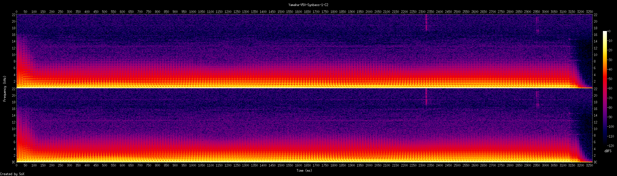
First we do the conversion to *.wav files from mp3
from pydub import AudioSegment
print("Converting...")
arr = [2,3,4,5]
for x in arr:
    sound = AudioSegment.from_mp3("{0}.mp3".format(x))
    sound = sound.set_channels(1)
    sound.export("{0}[WAV].wav".format(x), format="wav")
print("Converted.")
or Even this
from pydub import AudioSegment
sound = AudioSegment.from_mp3("KY.mp3")
sound.export("KY.wav", format="wav")
And then from *.wav to Spectograms
for file in *.wav;do
    outfile="${file%.*}.png"
    title_in_pic="${file%.*}"
    sox "$file" -n spectrogram -t "$title_in_pic" -o "$outfile" -x 2000
done
My friend had used this bash tool and this is a small script from his partially completed project… (There’s Librosa Module also, you can have a look…)
PS These aren’t mine(belongs to my friend); I have very little knowledge wrt music
Edit Added Working Demonstration -
- Download this wav file and run the above sox command to get this Spectogram…
3 Likes
I created an Age Predictor App 
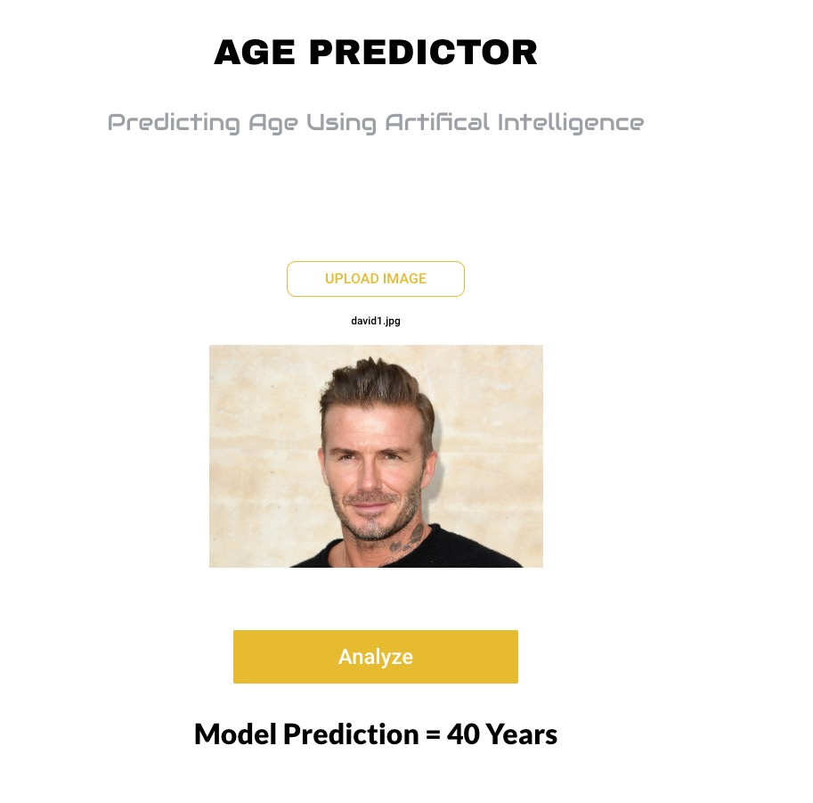
Basically used a pretrained Resnet-50 and trained it on IMDB-Wiki dataset (details in Github repo).
Maybe I am just being dumb but I am still not quite sure how to interpret the valid loss (MSELoss). It seems high but my predictions are not that far off…
Github: https://github.com/btahir/age-detector
Also gave a face lift to the Zeit front-end which you can see in the app. Feel free to use the index.html/style.css files for your projects.
You can check out the app here: https://age-predictor.now.sh/
14 Likes
Great work.
One application of this can be in Hotel review websites like Zomato, which categorizes user uploaded pictures as indoor, outdoor ambience and food.
Most probably they are already using similar ML technique.
1 Like
Can you share your notebook?
You’ve just made enemies with half of the world’s population.
6 Likes
Hi All,
Inspired by fast.ai Deploying web app to Zeit Production guide, I have created an updated starter packs that supports AWS Beanstalk, Google App Engine, also. Plus I have updated statics file with additional CSS & JS to handle big camera file uploads. Plus, These is started package for Keras image models also.
Then I also wrote a detailed guide to build & deploy these starter pack as a web app on 4 Cloud services, including AWS Beanstalk, Google App Engine, (Plus Azure Website & now.sh).
I hope to keep updating this guide with other Docker hosted Cloud web app services like Digital Ocean, Heroku, etc.
Plus more starter packs for NLP, Text or Collab Filtering.
Oh and This article is picked up by Towards Data Science Publication, so please let me know, your feedback, comments and thoughts here.
Download your starter pack app repository for Fast.ai here:
git clone https://github.com/pankymathur/fastai-vision-app
Download your starter pack app repository for Keras here:
git clone https://github.com/pankymathur/fastai-vision-app
Please do let me know your questions & feedback.
Thanks,
Pankaj
30 Likes
Wonderful work… Pankaj 
1 Like
Thank You Vishal, let me know, if you face any issue during deployment.
1 Like
Yeah sure…!
Thanks for this. I will try this soon…
1 Like
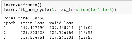
After some effort, I got it partially working. It reached 92.1% accuracy (0.3% bellow my previous model). Some remarks:
- I think there is some bug in my code, since when I try to run fit_one_cycle, after unfreezing and lr_find I get a “can’t optimize a non-leaf Tensor” error (it only happen when unfreezing and running lr_find before training). I wasn’t able to find out what is causing it.
- I only created two groups layers: the first containing the tabular and nlp models and the second containing the last linear layers. So, it is leveraging just partially on discriminative learning rates, using the same LR for all the layers inside tabular and nlp models. I think this can be specially harmful for the nlp model, updating the weights aggressively in the early layers, destroying part of the pre-trained weights.
Edited: I managed to set the layer_groups properly. In addition to minor tweaks (increase wd and dropout), I reached 92.3%).
I’d love to get some feedback and possible improvements.
4 Likes
Hi All,
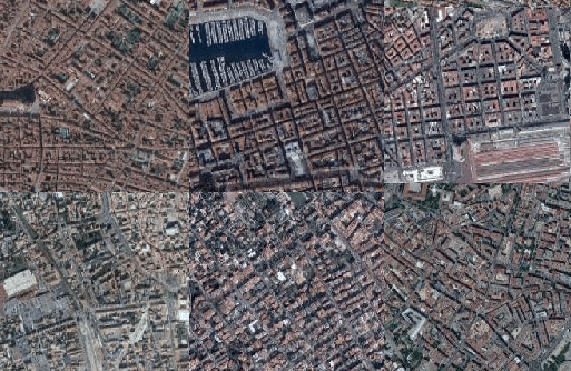
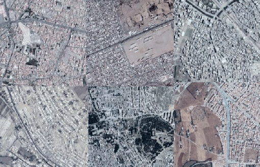
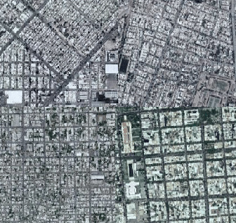
Yet another update on my satellite project. Yesterday’s lecture about PCA got me thinking about latent space representations for urban characteristics of cities as seen from space.
I tried doing PCA on the later layer’s vector representations of cities, but the results were a little disappointing, so in the end I used U-MAP to do my dimension reduction. It’s much faster than T-SNE and I thought the results were pretty cool.
I also flattened the U-MAP representation to a grid using the lapjv python package which finds the grid representation of distance maps using some fancy algorithm.
Here is the result:
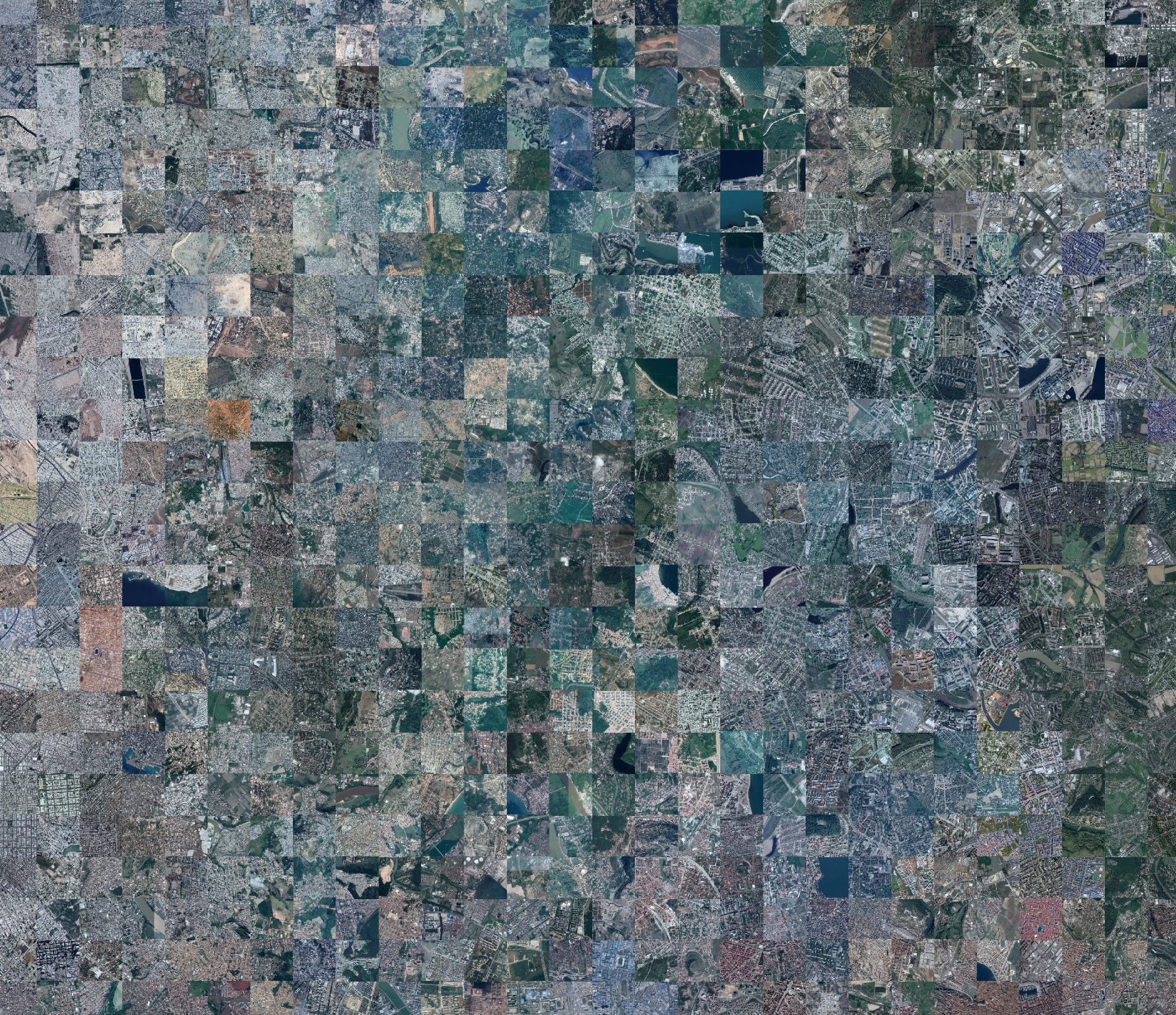
The actual image is 80MB so here are some interesting higher res areas:
Ochre roofs and twisty roads:
Big backyards:
Dense and arid:
Grids:
You can check the notebook out here
30 Likes
Very interesting!
Thanks for sharing the notebook and the data plus the scrapper as well
PS 37MB Jupyter Notebook!
Biggest of all I have seen till date
Nbviewer Link Of the Same Notebook https://nbviewer.jupyter.org/github/henripal/maps/blob/master/nbs/big_resnet50-pca.ipynb
Using this we can now detect Roof Top Swimming Pools maybe…
Just saying!
1 Like
Sure Amit, let me know if you face any issue during deployment.
Hi everyone,
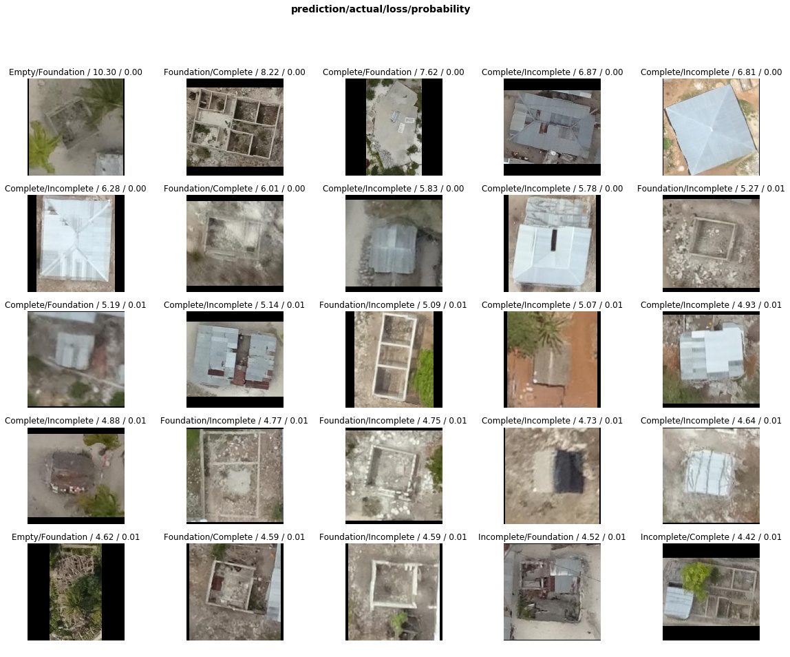
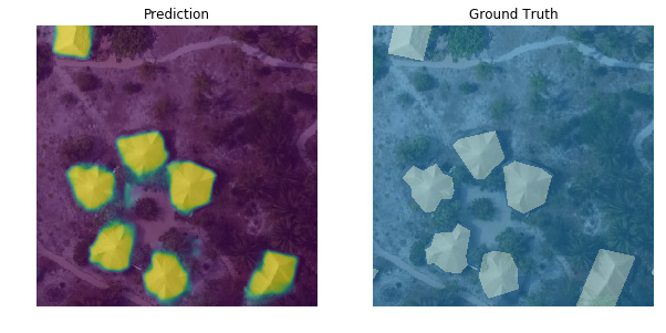
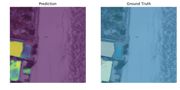
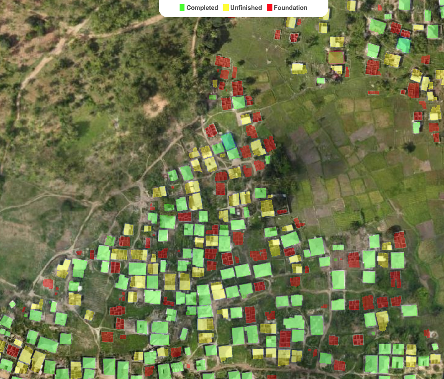
I’m excited to share new developments on segmentation & classification of buildings from drone/aerial imagery in Zanzibar, Tanzania:
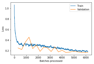
Updated building classifier to work with fastai v1.0.28 and trained the model to >94% accuracy. Looking at train/val loss, could keep training to get even better accuracy. Almost every top-loss prediction error is because of mislabeled ground truth data so some ImageCleaner action would definitely help:

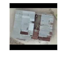
Added Grad-CAM code from @henripal (much thanks for the discussion & notebooks!) to aid in model diagnostics and interpretability. Exploring under the hood to see what insights and ideas for improvement we can get about the model’s behavior.
Here’s looking at individual feature map channels ranked in importance as the sum of gradients for that channel calculated by back-propagating from the one-hot-encoded class prediction (a “Complete” building in this case). In other words, what specific feature maps (out of 2048 channels in my case) are most important to classifying this image as “Complete” and what are they looking at (activating on):

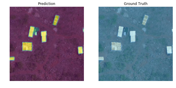
I’ve also created a new segmentation model based on lesson-3 camvid which handles the first part of the overall task (segment every pixel as building or not building). As mentioned in my 1st post, I originally used the old fastai v0.7 library so I’m bringing everything up to v1 now. Performance is not up to that of my old model yet but I’m haven’t done any optimizations. Off-the-shelf fastai v1.0.28 for binary segmentation using a pretrained resnet34 encoder already gives pretty satisfying results (pixel-wise accuracy > 0.98, dice score > 0.85):
Here are both notebooks:
- Classifier notebook: https://nbviewer.jupyter.org/github/daveluo/zanzibar-aerial-mapping/blob/master/znz-classify-buildings-20181119.ipynb
- Segmentation notebook: https://nbviewer.jupyter.org/github/daveluo/zanzibar-aerial-mapping/blob/master/znz-segment-buildingfootprint-20181119.ipynb
I’ve also open-sourced my pre-processed training data for both models so anyone who wants to work with these notebooks can have ready-to-train data without going through the somewhat-niche data prep to convert geoJSON polygons into binary masks or crop individual buildings into images. For anyone interested in those steps, I will post them as well in future notebooks. Data download links and more info at the repo here:
Much thanks to the Commission for Lands, Govt. of Zanzibar and WeRobotics via the Open AI Tanzania competition for the original drone imagery and training labels. They are made available under Creative Commons Attribution 4.0 International license.
My overall project goal is to keep improving these models and publish notebooks showing the DL model development as well as all the intermediary geospatial data processing steps to make this:
Interactive demo link: http://alpha.anthropo.co/znz-119
Dave
55 Likes